Bilaspur – Overview, History & Infrastructure
HistoryHistorically, Bilaspur was a part of Kalchuri dynasty of Ratanpur. The city, however, came into prominence around 1741, the year of the Maratha Empire invasion, when a Maratha official took up his abode there and began to build a fort, which however was never completed.
The city was taken over by the British East India Company of Great Britain in the year 1854 when the then ruler of the region, Bhosale of Nagpur belonging to Maratha Empire died without an heir. The management of Bilaspur district was taken over by the British Government in 1818, before this it was under harsh, extortionist Marathaan rule for about 60 years. Bilaspur district was constituted in 1861, followed by Bilaspur municipality in 1867.
Famines in the Bilaspur district were recorded by the British administration in 1828-9, 1834-5, 1845-6, 1868-9 and 1899–1900. In 1868-9 and 1899–1900, the rains failed almost completely, resulting in severe distress, migration and desertion of villages. After the 1868-9 famine there was prosperity for the next 25 years; but in 1895 there was a very poor harvest, followed in 1896 by a complete failure of crops, and severe famine continued throughout 1897. In that year the mortality rate was as high as one in six people.
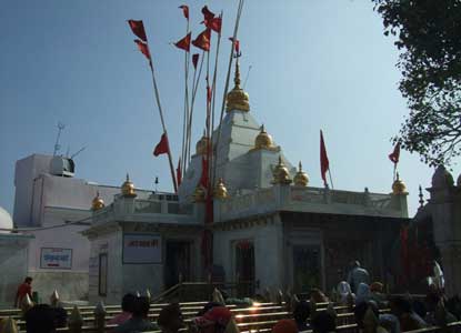
The famine of 1897 was followed by two favorable years but in 1899 the monsoon failed completely and the rice crop was wholly destroyed.Guru Ghasidas (1756–1836) started a religious movement Satnamis (meaning the worshippers of Satnam) between 1820 and 1830 primarily around the Sonakhan forests. This religious movement preached that god is not idols or not found in idols but god is synonymous with truth. His community was a farming community, though in Hindu caste hierarchy they have been put in the Schedule caste. The university at Bilaspur is named after him as Guru Ghasidas University.
Railways arrived at Bilaspur in the decade 1880-90, with the arrival of the Bengal Nagpur Railway. In 1888 Mistri Jagmal Gangji laid the first railway tracks from Rajnandgaon to Bilaspur,and in that same year fellow Kutchi contractor Mistri Khoda Ramji built the line from Bilaspur to Jharsuguda, including the bridge over the Champa river.In 1890 the present railway station and yard were constructed by the famous Gujarati railway contractor Jagmal Gangji.
His son Mulji Jagmal Sawaria was later given the title of “Rao Sahib” by the British for his contribution to the development of the town, railways and the district. Jagmal Block and Jagmal Chowk in the city are named after Jagmal Gangji Sawaria.In 1901, the population of Bilaspur was 18,937 and it was eighth-largest town in the Central Provinces of British India. In 1908, weaving of tasar silk and cotton clothes were recorded as the major industries of Bilaspur.
General Information
- Population: 330,106
- Area:1,167 km
- Literacy: 87.29%.
- Tehsils: Bilaspur Sadar, Ghumarwin, Jhandutta.
- Sub-Tehsils: Shri Naina Devi Ji and Bharari.
- Sub-Divisions: Bilaspur and Ghumarwin
- Panchayat: 151
Map

Demographics
As of 2011 India census, Bilaspur had a population near about 4,54,000.Final population data are yet to come which is estimated near about 6,00,000.Males constitute 51% of the population and females 49%. Bilaspur has an average literacy rate of 87.29%, higher than the national average of 74%; with male literacy of 92.94% and female literacy of 81.33%. 15% of the population is under 6 years of age.
Climate
The climate is pleasant and mild in the winter ( minimum temperature 10 °C, 50 °F). There are medium rains in the monsoon season. The summers are very hot and dry maximum temperature 45+ °C, 113 °F, maximum humidity.
How To Reach
By Air
Chandigarh and Bhuntar are the nearest airports, located at 135-km and 131-km from Bilaspur.
By Rail
The nearest broad gauge railway station is at Kiratpur Sahib and the nearest narrow gauge railway station is at Shimla.
By Road
Deluxe Buses and even ordinary Buses are available from Chandigarh to Biaspur via Kiratpur on the way to Manali crossing Mandi and Kullu.